Winston Co. Pictures

Downtown Louisville,
in 1950s, Dairy Day Parade. Winston County use to be a big dairy county
and had two dairies from which you could buy.
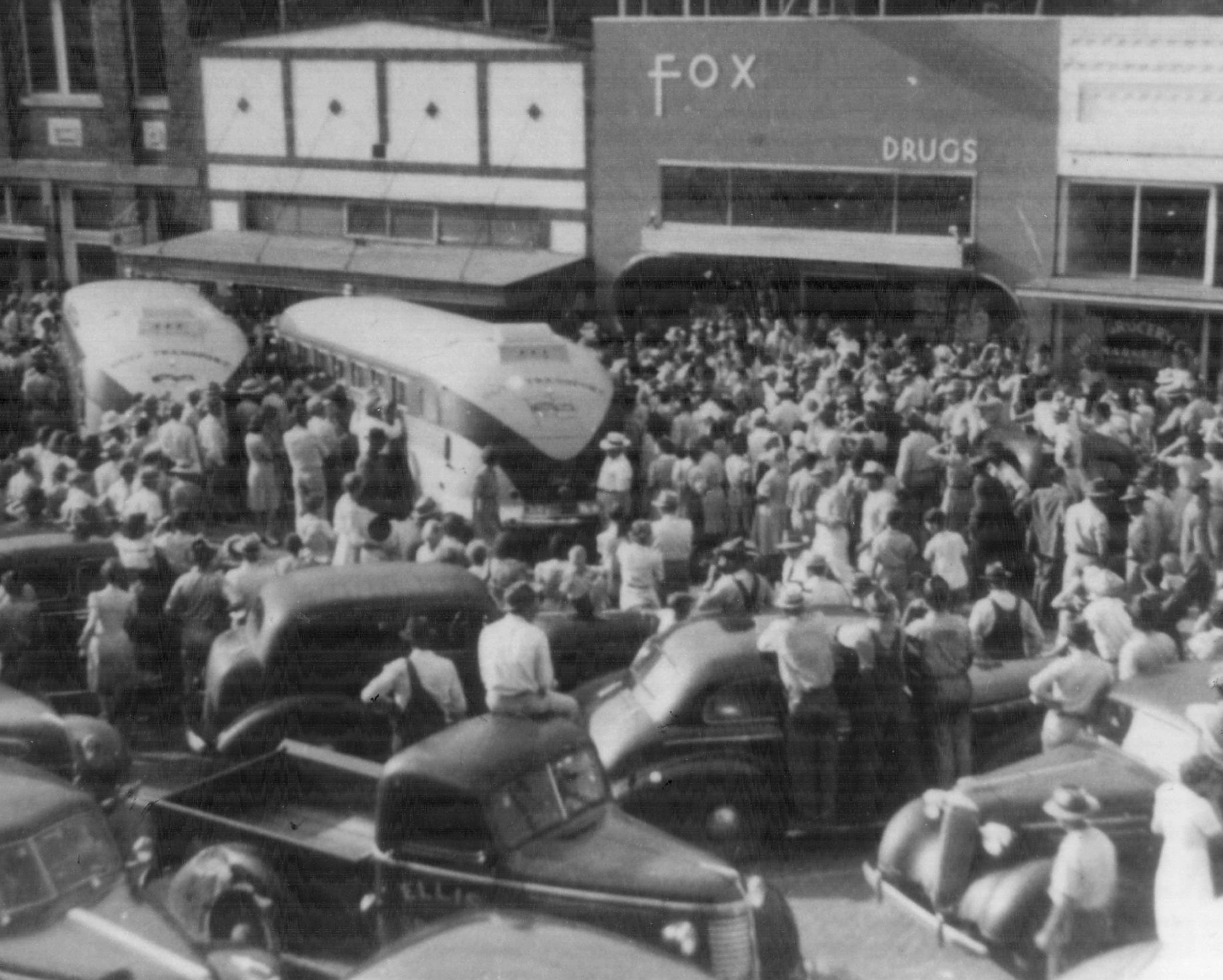
Off to War
(WWII). This is downtown Louisville, 1940s, when buses came to pick up
all the men to go to war. A moving picture when you think of all the
people affected by this war.
B. Forster
Performing genealogical work regularly!
Argo
Argo, now extinct, was established in 1909 as a sawmill and flag
station on the G M & N Railroad one mile south of Hight. The place
became extinct in 1926 and now no trace of it can be found, except
perhaps a sawdust pile.
Betheden
Located nine miles northeast of Louisville, Betheden took its name
from an early Lutheran Church located near the center of the community
in 1848. Jesse Morgan was the first preacher at this church which was
named by the people; its name being built from the Hebrew word, Bethel
which means House of God, and the word Eden meaning Pleasant Worship.
William Kinard, a pioneer citizen, built a house here in 1850 which was
also used as a stage coach stop. K. A. Livingston was a pioneer citizen
who operated the first sawmill here.
Boon
Boon, six miles east of Louisville was named by the Post Office
Department on the establishment of an office in 1860. This office served
the community until it was abolished with the advent of Rural Free
Delivery. The Barnhill family were among the earliest setters on this
site.
Cagle
Settled in 1835, about sixteen miles northeast of Louisville, Cagle
was named for the Pink Cagle family who were early settlers. The place
was never more than a farming community and was extinct by 1900.
Calhoun
Calhoun, fourteen miles southeast of Louisville, came into being in
1920 with the establishment of the Calhoun Consolidated School, named
for J. C. Calhoun.
Calvary
Located five miles southwest of Louisville, Calvary was established
prior to 1920 and was first known as Coulter. The name was changed to
Calvary in 1914 for the Calvary Baptist Church.
Caney
Caney, ten miles southeast of Louisville, was established in 1835 by
settlers from North Carolina and named for nearby Caney Creek. William
Terrell Lewis, first surveyor of the county and descendant of Meriwether
Lewis of the Lewis and Clark expedition is buried here.
Claytown
Claytown, seven miles east of Noxapater, was settled in 1880 by the
Clay family who moved here from Kemper County. There was a post office
here at that time which was operated in connection with the one store in
the village.
Coopwood
Coopwood was an agricultural community which was settled in 1835
about twelve miles south of Louisville and was named for Coopwood Creek
which ran through the community.
Cork
Cork, twelve miles southeast of Louisville, was settled by the
Whitehead family in 1850 and established as a post office in 1890 with
Dr. A. A. Guthrie as postmaster.
Cornwell
Cornwell was established as a post office in 1846 ten miles southwest
of Louisville. The place took its name from a family by that name who
moved here from Alabama.
Ellison Ridge
Located twelve miles east of Louisville, Ellison Ridge was named for
William Ellison who settled here in 1834, being followed the next year
by the Moody and Eaves families. The Moody family operated a water mill
here for well over one hundred years.
Estes
Located four miles south of Louisville, Estes was named for W.W.
Estes who built and operated the first sawmill here in 1900. At its peak
Estes consisted of four stores, the mill commissary, a post office, the
Flower Ridge Methodist Church and a small school which consolidated with
Noxapater in 1934.
Evergreen
Evergreen, five miles northeast of Louisville, was established in
1866 by the Bouchillion, McCully and Robinson families. A Baptist Church
was organized in the community in 1892.
Fearn Springs
Located four miles northeast of Handle, Fearn Springs was settled
before 1860 and named for the abundance of ferns in the area with the
word fern being spelled Fearn. The land is hilly and from its natural
arrangement the locality has been called The Skillet. After the Civil
War Fearn Springs became a thriving place, consisting of a post office,
three stores, two churches, a school and several residences surrounded
by five water mills and gins. The stores were owned by James and Johnnie
Chappell, T. Anderson and J. Moody. A blacksmith shop was run by Ben
Rodgers and the two doctors who served the village were Drs. Kirk and
Eskridge. The water mills were operated by J. Moody, James Chappell,
Captain John Holmes, George E. Haynes and Peter B. Smith. On July 31,
1936 the Choctaw Indians assembled here in hundreds to celebrate the
anniversary of the signing of the Treaty of Dancing Rabbit Creek. All
night clans and families poured in and the whole town became a camp
ground, although Dr. Kirk's pasture had been designated as the official
grounds for camping. The festivities, which consisted of mostly eating
and playing ball lasted for two days.
Ford
Settled in 1835, eight miles west of Louisville on what was known as
the Wire Road, this settlement was formerly known as Simonfield. About
1920 when the school was consolidated the name was changed to Ford in
honor of Henry Ford.
Gum Branch
Gumbranch or Gum Springs was established twelve miles north of
Louisville in 1845 around the Gumbranch Baptist Church. Early settlers
in the community included the Porter, Weeks, Long, Bailey, Gill and
White families.
Gypsey
Gypsey was the name of a post office located near the Gumbranch
Community twelve miles north of Louisville. This site was settled in
1835 by Allen Neighbors, Ezekiel Barron, William Shaw, Allen Crosby and
Samuel Hyde. On the establishment of a post office, William Griffith
served as postmaster until the office was discontinued in 1902. An early
school in the community known as Shaw Spring was consolidated with
Gumbranch in 1925.
Haggard
Part of the Ellison Ridge Community about fifteen miles east of
Louisville, Haggard was established in 1850 and named for Robert Haggard
who was a prosperous farmer here at that time.
Handle
Located eleven miles southeast of Noxapater, Handle was named for the
contour of the surrounding land. The hill in this part of the county
forms a large figure in the shape of a skillet and a narrow strip
stretching evenly from this point to the Kirk Plantation is called the
Handle, giving the name to this neighborhood.
High Point
Located seven miles northwest of Louisville, this site was first
called Hathorn for James Hathorn, but the name was changed because of
another post office with the same name. When the G M & N Railroad was
built in 1905, a station was required in this neighborhood, and here -
where the railroad grade was high - was selected as the most suitable
place for the town, which was accordingly named High Point.
Hight
Hight, three miles south of Noxapater, was started when the Noxapater
Lumber Company established a sawmill here on the G M & N Railroad near
the farm of Charles Hight. The lumber company, which was owned by Harry
Wright, moved it's mill in the early 1930s, leaving approximately twelve
families in this area.
Hinze
Hinze, a country community located fourteen miles southwest of
Louisville, was settled about 1872, and took its name from the most
prominent family in the community. The community is composed of a group
of farm families who live close together along a country road.
Joplin
The site of Joplin, seven miles east of Louisville, was settled in
1837 but was not named Joplin until a post office was established and
the Postal Authorities selected the name. The post office did not
operate for a long period of time as James Bouchillion was its only
postmaster; the office being abolished with the coming of Rural Free
Delivery.
Lettie
This location, about thirteen miles southeast of Louisville, was
first settled in 1835. A post office operated from 1890 until 1910,
which was named "Lettie" - for the wife of John Lovorn, a landowner.
Liberty
Located in the southwestern part of the county about five miles from
the Neshoba County Line, Liberty was never more than a small settlement
which grew up around the Liberty Consolidated School once located here.
Loakfoma
Loakfoma, a rural settlement located thirteen miles northeast of
Louisville is an Indian name, the word meaning Red Clay; a perfect
description of the soil in the vicinity. At one time there was a school
here which served as a center for a wide area.
Louisville
Louisville was originally platted on a twenty acre tract of land
donated by Jesse Dodson who took a leading part in the organization of
Winston County in 1833. The town soon became a trading center and was
incorporated in 1836, being named for Colonel Louis Winston, an early
settler who was once an Attorney General in the Tennessee River Country.
The exact beginning of the town is not known but it is certain that a
small store and blacksmith shop was created on the site in 1828. The
building of the G M & N Railroad in 1905 gave the town a boost in growth
but at the same time deprived it of some advantages as a trade center by
giving other towns equal railroad facilities.
Louisville has a
monument to Winston County's support of the Confederacy, the Spanish
American War and World War I.
McMillan
McMillan, better known as McMillan's Switch, was established as a
flag stop on the G M & N Railroad five miles northwest of Louisville.
Its name was taken from the only white family living here at the time
the station was built.
Mill Creek
Mill Creek, established in 1837, is a country community located seven
miles northeast of Louisville. There was never a post office or anything
of a town here, but years ago on a nameless branch of Nanih Waiya Creek
there was located a small portable sawmill from which the name Mill
Creek was derived.
Nanih Waiya
Located nine miles southeast of Noxapater, Nanih Waiya is an Indian
name meaning Slanting Hill and is the sacred mound of the Choctaw which
occupies a unique tradition in Choctaw tradition in that it is connected
with both the creation and migration of the tribes. The mound is called
Great Mother and is looked upon as the birthplace of the Indian Race;
being the center of Choctaw life before the coming of the white man. The
Choctaws believe that many years ago the Muskogee first came from the
mound and sunning themselves on the rampart until dry went eastward.
Next came the Cherokee who after having dried themselves followed the
trail of the older tribe. Then came the Chickasaw who settled and made a
people to the north. At last came the Choctaw who dried themselves then
settled about the mound; their Great Mother who told them that if they
ever left her side they would die. When the Government remembered its
century-old debt to the Choctaws and established the Indian Agency in
1918, most of the tribe who remained were found to be living near the
sacred mound and the legendary promise of protection. About 250 yards
north of Nanih Waiya is another mound, a small one where according to
Choctaw legend, corn was first presented to the world. Soon after the
Choctaw had settled a crow brought a single kernel of corn across the
great water (Gulf) and gave it to an orphan child named Tonchi (Corn)
and planted it. When it came up he hoed it, hilled it and laid it by; so
began the cultivation of maize.
New Prospect
Located about fourteen miles north of Louisville, New Prospect was a
small settlement gathered around the New Prospect Baptist Church. Many
years ago another church at this location was disbanded but new arrivals
in the community, along with older citizens, organized a new one which
they called New Prospect.
Noxapater
An old village located nine miles south of Louisville, the name
Noxapater is said to be of Latin origin meaning Dark Father. The name is
also said to be of Indian origin meaning Trigger. Whichever the origin,
the name was suggested by Dr. J.G. Gunn, an early settler. Noxapater was
incorporated in 1906 and at that time was a progressive trading center
with two cabinet shops and two cotton gins in operation.
Perkinsville (historical)
Perkinsville, a rural settlement about thirteen miles east of
Louisville, was settled during the years 1835-1853. The settlement was
named for a Perkins family who settled here in 1870.
Plattsburg
Located eight miles southwest of Noxapater, Plattsburg was settled in
the late 1840s and by 1862 had become a post office which served an area
as far as the northern part of Neshoba County. Life was rough, as were
the settlers, and like seems to have attracted like - until the town
acquired the nickname of "Fort Growl" because its inhabitants were given
to getting drunk, growling and causing trouble to such an extent that a
network of feuds sprang up. In spite of this, these people were very
enterprising because by 1890 Plattsburg was a thriving town consisting
of a hotel, three churches and a printing plant which published The
Vigilant, a weekly newspaper. An academy was also located here,
consisting of twenty-four rooms which were heated by twelve chimneys.
When the railroad was built through this area it missed Plattsburg, and
the start of the town's decline began.
Presnell
Presnell was named for the man who operated a sawmill on this site
about 1900, six miles south of Louisville. After the timber had been cut
the mill moved and Presnell became extinct.
Randall's Bluff (historical)
This area, nine miles southeast of Louisville, was settled between
the years 1835-1847 but Randall's Bluff was never a town, it was only
the point where a road crossed Nanih Waiya Creek. It is not known why
the place was named Randall's Bluff.
Ross
In 1912, Ross was the site of a sawmill and a flag stop on the G M &
N Railroad five miles south of Louisville; the place taking its name
from a family who owned a farm near the sawmill. Later the family moved
away, the mill closed and Ross became extinct.
Rural Hill
Rural Hill, a farm community four miles northwest of Hinze, took its
name from its location. Henry Vanlandingham was the first settler
purchasing land in 1838. In 1860 the Blaine, Lowery, Williams and Ray
families moved into the area. One mile south of Rural Hill is Lobutcha,
which merged with Rural Hill to form a large settlement with the
consolidated school serving as the community center.
Singleton (historical)
Singleton, thirteen miles northeast of Louisville, was never more
than a country post office which became extinct with the coming of Rural
Free Delivery in the early 1900s. The origin of the name is not certain.
Sulphur Springs
Sulphur Springs, three miles northeast of Louisville, was established
prior to 1850. During the 1850s this was a popular resort town where
people came to drink the water and enjoy the accommodations of a
twenty-seven room hotel complete with ballroom, bowling alley and pool
room. A novel swing at the hotel, which seated eight to ten persons was
built to swing out over the marshes below, giving a thrill to those who
dared ride it. The hotel burned in 1876 and a smaller one was built, but
by the mid-1930s nothing was left of the place except the spring and the
large beech trees on the site.
Tampa
Tampa was an early rural post office located eleven miles west of
Louisville which was named by the Post Office Department. It became
extinct with the advent of Rural Free Delivery.
Tripletts Corner
Tripletts Corner or Tripletts Town, located fifteen miles east of
Louisville, was named for the Triplett family who settled here in 1850.
There was no school or church in the settlement, the children attending
school in Mashulaville and church being attended at Perkinsville.
Vowell
Vowell or Vowell Town, located ten miles west of Noxapater, was
settled in 1850 but never consisted of more than a few farm houses built
close together. 
|