WEBSTER COUNTY
Chapter XLVIII, pages 854-855
The boundary lines of the counties of the
State have undergone many changes brought about by the formation of new
counties out of several whose territory was larger than necessary.
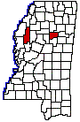
Webster County, in northeast-central Mississippi,
was established April 6, 1874, under the name of Sumner County, and was
organized from parts of Chickasaw, Choctaw, Montgomery and Oktibbeha counties,
On January 30, 1882, its name was changed to Webster, in honor of the great
statesman, Daniel Webster. The present county has a land surface of 416
square miles. The old boundary line between the Choctaw and Chickasaw cessions
cuts across its northeast corner, and Calhoun and Chickasaw counties lie
on the north, Clay County on the east, Choctaw County and a corner of Montgomery
on the south and Montgomery and Grenada counties on the west.
By the act creating the county, the Governor
was authorized to appoint and commission five persons to act as a Board
of Supervisors, to proceed at once to organize the new county, and was
also empowered to appoint the usual county officers. The following officers
were appointed by Governor Ames in compliance with the foregoing provision:
Ira McDowell, President, David Nowlin, G.W. Pollan, J.W. Starnes, Aaron
Smith, members of the Board of Supervisors; J.W. Holland, Sheriff; Dr.
W.A.F. Caldwell, Clerk of the Chancery and Circuit Courts; Aaron Hutto,
Treasurer; R.F. Holloway, Superintendent of Education. The act further
recited that the county site should be determined by a vote of all the
people of the new territory, which placed it at Walthall, near the geographical
center. Meanwhile courts continued to be held at Greensboro, the old county
seat of justice for Choctaw County until 1876. This old town was located
in section 8, twp. 19, range 9, east. It once had about 250 inhabitants
and some ten business houses. Its courts were attended by such men as J.Z.
George, Reuben Davis, E.C. Walthall, Wiley P. Harris and Bob Hudson. Its
most prominent citizens in the early days were J.V. Steen, Wiley Marshall,
Frank Liddell, T.N. Davis, John Nolen, Capt. J.B. Dunn, Col. Wm. Brantley,
and J.J. Campbell. It was a favorite stopping place for legislators en
route to Jackson 120 miles away, via the old Natchez Trace. The old town
was burned during the war, and the court house in 1871, when the place
began to rapidly decay. The old log jail in 1839 or 1840 was the last of
Greensboro to disappear.
Among the early representatives of the
county in the legislature were M.A. Metts (1876-78), J.E. Bridges, S.M.
Roane, T.N. Davis and S.E. Parker. The county seat is Walthall above mentioned
named for Gen. B.C. Walthall, and it is but a hamlet away from railroad
connection in the center of the county. There are no large towns in the
county, Eupora, on the Southern railway, with a population of about 900,
being the largest. Other railroad towns are Mathiston, Sapa and Tomnolen.
Two railroads supply transportationthe Southern, which follows the southern
border of the county, and the Gulf, Mobile & Northern, which runs through
the eastern portions from north to south. The Big Black River and its tributaries,
Little Black and Sand creeks; and Sabola, Shutispear and Tupashaw creeks,
tributaries of the Yalobusha River, are the principal water courses. Webster
is termed a hill county, but the land is level on the bottoms, and portions
are undulating. The black-jack and pine lands are poor, the bottom soils
very good, and the undulating lands of average fertility.
The Federal census for 1920 gives the following
facts relating to the agricultural activities of Webster County, the information
covering the year 1919: Value of all farm property, $4,800,000; value of
crops, $2,327,000, of which the cereals were estimated at $726,000, vegetables
at $248,000 and hay and forage at $206,000. The area cultivated to cotton
was reported at 13,000 acres and the production at 4,700 bales. The live
stock was valued at $878,000.
Webster County has not increased in population,
as a whole, from the time of the taking of its first census in 1880 to
the present, or at least to 1920. In 1880, its population was 9,534; in
1900 13,619; in 1920, 12,644.