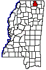
TIPPAH COUNTY
Chapter XLVIII, pages 835-838
Tippah County, which adjoins the Tennessee
border in the northeast corner of the State, was established February 9,
1836, and was named for the wife of Pontotoc, a Chickasaw Indian chief,
the name signifying cut off. It was one of the twelve counties created
out of the Chickasaw cession of 1882. It was originally a very large county
of about 27 townships and embraced within its area a large part of the
present county of Benton, as well as the northern portion of Union and
the western portions of Alcorn and Prentiss counties. Its original limits
were defined as follows: Beginning at the point where the line between
townships 6 and 7 intersects the basis meridian, to the northern boundary
line of the State; thence east with the said boundary line, to the line
between ranges 5 and 6 east; thence south with the said range line, to
the line between townships 6 and 7; and thence west with the said township
line to the beginning. In 1873, parts of the original county were detached
to form parts of Alcorn, Benton and Union counties, reducing it to its
present area, 446 square miles. It is now bounded on the north by the Tennessee
line, on the east by Alcorn and Prentiss counties, on the south by Union
County and on the west by Benton County. A list of the county officers,
soon after the establishment of the county, is as follows: Joseph Hicks,
George Gray, Robert P. Dean, Thos. C. Nanty, Samuel Long, Members of the
Board of Police; John B. Ayres, John Redfern, James Parke, Hugh G. Henderson,
Daniel Cuthbert, Wm. McGraw, John C. Blackwood, Josiah Short, Joseph Smith,
David Skilman, Magistrates; John Jones, Allen Ayres, Hiram Oney, Handy
B. Byrn, James M. Clark, Constables; Robert R. Thomas, Judge of Probate;
Edmund J. Bailey, Clerk of the Probate Court; Henry W. Stricklin, Clerk
of the Circuit Court; Samuel N. Pryor, Assessor and Collector; Daniel Griffin,
County Treasurer; Wm. Kerr, County Surveyor; Winston Corter, Coroner.
Many wealthy and substantial planters,
merchants and professional men came to the region in the early 30s, and
settled along the banks of its streams. Among the early settlements of
those years, which flourished for a time, but are now moribund, may be
mentioned Salem, Orizaba and Ruckersville. Salem was first settled in 1836,
incorporated 1837. It was two or three miles west of Ashland in what was
then Tippah County, and was absorbed by the latter place. Among the more
prominent settlers of the neighborhood were Col. Francis T. Seake, Thomas
Hamer, Col. Daniel B. Wright, lawyer and Congressman; Col. John B. Ayres,
father of Gus Ayres, M.D.; Robert McDonald, Dr. J.A. Moorman, John W. Matthews,
Orin Beck, proprietor of Becks Springs, and Col. Baird, Major-Gen. N.
B. Forrest, the renowned cavalry leader and a nephew of Mr. Beck, and Joseph
W. Matthews, once Governor of the State, also lived near Salem. Orizaba
was 7 miles south of Ripley and once had one hundred and fifty inhabitants.
Its people lost heavily during the war and the building of the Gulf &
Chicago (Gulf, Mobile & Northern) railroad a few miles to the east,
and the establishment of the large female college, at Blue Mountain, by
the late Gen. M.P. Lowrey, three miles to the northwest, worked the final
ruin of the old town. Many prosperous planters were located in the surrounding
country, and local residents were: Robert I. Hill, W.T. Ratcliff, Noah
Roberts, Laird and Wear, merchants; Laird, Magill, Ford, Ellis and King,
physicians. Ruckersville was settled in 1842 by John and Daniel Finger
and first called Fingers Cross Roads, from its location where the Ripley
and Pocahontas and Salem public roads cross. Soon after Dr. Charles Rucker,
an able physician, established a drug store here and the place took his
name. Fant, Gibbs & Co., did a thriving mercantile business here until
the coming of the railroad to Ripley, 5 miles away. Some of the earliest
settlers in the county besides those above mentioned, were Abner McCoy,
Joseph Jamison, W.C. Falkner, lawyer, author and colonel in the Confederate
service; Rev. Wm. A. Gray, Hon. W.A. Boyd, Judge Christopher A. Green,
Thos. C. Hindman, father of Gen. Thos. Hindman; Dr. E.M. Alexander and
Frederick Brougher, Senator from Tippah in 1842, 1843, and 1844, father
of Charles Brougher, afterwards Secretary of State. The Brougher home,
Blue Mountain, 6 miles from Ripley, was one of the famous historic homes
of Mississippi.
The county seat of Tippah is Ripley, near
the center of the county on the Gulf, Mobile & Northern railroad. It
is a place of 900 inhabitants (incorporated May, 1837), the center of a
good trade from the surrounding country and is possessed of excellent schools.
Six miles southwest of Ripley is the town of Blue Mountain, so called from
the mountain of the same name, and a. place of 700 inhabitants. Here is
located the institution known as the Blue Mountain Female College, founded
by Gen. M.P. Lowrey, in 1873, on the site of the old Brougher home. Some
of the other towns are Cottonplant and Faulkner, on the railroad, and Graves,
Hatchie, Dumas, Bullock, Mitchell, Chalybeate and Silversprings, away from
the road. A single line of railway traverses the county (the Gulf, Mobile
& Northern) from north to south, connecting with the St. Louis &
San Francisco system at New Albany, Union County, and with the Southern
railway at Middleton, just across the Tennessee border. The county is watered
by the head streams of the Tallahatchie and Tippah rivers, on the west
and south, and by the West Hatchie and Hatchie rivers, on the east and
north. The eastern part of the county lies in the so called Limestone formation
and the western part in the Yellow Loam region. The soil readily produces
corn, cotton, fruits and vegetables. Considerable live stock is also raised.
The statistics furnished by the Federal
census of 1920 indicate the following: That Tippah County has a farm valuation,
including lands, buildings, implements and live stock, of $7,250,000; that
the value of its crops in 1919 was $3,315,000; that the live stock was
assessed at $1,483,000, and that of this sum last named dairy cattle were
valued at $379,000 and their products brought $179,000 to the farmers in
1919.
The population of Tippah county has naturally
varied. From 1850 to 1870, inclusive it varied from 20,000 to 22,000. Since
1880, after it gave up so much of its territory to new counties, its population
has ranged from 12,000 to 15,000. In 1920 it was 15,419.