NOXUBEE COUNTY
Chapter XLIV, pages 799-803
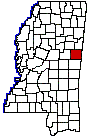
Noxubee County is located in the fertile
prairie region of eastern Mississippi, on the Alabama border. It was established
December 23, 1833, and its name is derived from an Indian word, as are
many of our geographical names.
Noxubee County is bounded on the north
by Oktibbeha and Lowndes counties, on the east by the State of Alabama,
on the south by Kemper County and on the west by Winston County. It is
one of the sixteen counties formed from the Choctaw cession of 1830 and
its original boundaries were as follows: Beginning on the Tombeckbee River,
at the point at which the line between townships 16 and 17 strikes the
said Tombeckbee River, and from thence west with said line between townships
16 and 17, to the line between ranges 14 and 15 east; and from thence south
with said line between ranges 14 and 15 east, to the line between townships
12 and 13; from thence east, with said line between townships 12 and 13,
to the line between the State of Alabama and the State of Mississippi,
and from thence a northern direction with said line . . . to the Tombeckbee
River, and from thence up said river to the place of beginning. The original
limits as thus defined have not been changed. The total area of the county
is about 18 townships, or 682 square miles.
Two of the early settlements were at Boundstown,
so called from its first settler, Jesse Bounds, and the town of Brooklyn.
Boundstown never got beyond the rough country village stage, and was soon
absorbed by the neighboring town of Brooklyn, situated on the Noxubee River,
eight miles east of Shuqualak. Loomis Bros. and Hinzy Walker were early
merchants here. The river never proved to be navigable for steamboats,
and by the outbreak of the War for Southern Independence the town was dead.
It was in this county, between the two
prongs of Dancing Rabbit Creek, that the famous treaty of Dancing Rabbit
was made and signed, September 27th, 1830, whereby the Choctaw Indians
relinquished to the United States all their remaining lands east of the
Mississippi. The commissioners for the United States were Maj. John H.
Eaton and Col. John Coffee. Some six thousand Indians, men, women and children,
from first to last were encamped on the creek, and participated in the
discussions leading up to the treaty through their Mingoes, chiefs, captains
and warriors, chief among whom were the celebrated Colonel Leflore, Mu-shu-la-tub-bee,
Nittakechi and Little Leader. Eye-witnesses to the signing of the treaty
were two pioneer settlers of the county, Hilcar Burwell and G.W. Campbell.
Other early emigrants to the region were William Darroh, Thompson Allen,
J.L. Higginbotham, Isham Harrison, Wm. Colbert, W.C.H. Finley, Thomas Ellington,
Felix H. Walker, J.T. Harrison, C.W. Allen, Thomas H. Dixon, Hezekiah W.
Foote, John Bartlett, William Woodward, Cyrus Lovelady, John Culbertson,
Edward Freeman, Shelton Standifer and H.L. Jarnagin.
The first court in the county was held
in the log house of Joseph H. Frith, on the present site of Macon, the
county seat. This little city of 2,000 people is pleasantly situated in
a beautiful valley, on the east bank of the Noxubee River, at the center
of the county. Here, in the late 30s, a two storied brick courthouse,
with porticoes and marble columns was built and used until a more commodious
building costing $60,000 was erected just before the war. The present fine
courthouse was erected in 1900. Macon is now a thriving place with several
prosperous manufactures and is the center of a large trade from the rich
farming country about it. The Mobile & Ohio railroad gives it excellent
shipping facilities.
Brooksville, with 850 people, Shuqualak,
about the same number, Cooksville, Mashulaville and Cliftonville, are the
more important towns. The Mobile & Ohio railroad runs north and south
through the center of the county. The Noxubee River runs a very crooked
course through the center of the county from the northwest to the southeast,
and, with its numerous tributary streams, provides the region with ample
water. The eastern two-thirds of the county lies in the black prairie belt
and possesses a rich, black soil, underlaid by rotten blue and white lime-stone.
The cotton lands in the eastern sections with the crops growing in them
present a pleasant prospect to the eye from the car windows. The soil is
rich and the fields are a living green much of the year. The western third
is rolling, timbered lands, with a rather light, sandy soil, and not so
productive, but well adapted to the raising of fruits and vegetables. The
county is rich, in the dim remains of Indian civilization and subjected
to the survey of the Smithsonian Institution being made in the State it
may supply many lost links in the history of the Choctaw Indians.
The government census bureau in its publications
for 1920 issued full reports of the condition and movements of agriculture
in all the Mississippi counties. Its figures covered, the year 1919. >From
them it is learned that the value of the farm property in Noxubee County
was $13,923,000, or nearly double that of 1910, while the value of all
its crops, as raised in 1919, was $3,692,000. The cereals accounted for
about a quarter of the total value and hay and forage about one-seventh.
The cotton fields of Noxubee County were spread over more than 53,000 acres
of land, and from them was gathered enough of the staple to make 8,600
bales. All the domestic animals of the county were valued at $1,935,000.
Most of that sum was accounted for by the mules, valued at $585,000, the
dairy cattle at $515,000. and the horses at $363,000.
The population of Noxubee County has varied
greatly from decade to decade, but, as a whole, has not much advanced.
In 1850, it was 16,299; in 1920, 23,710.