MONTGOMERY COUNTY
Chapter XLIV, pages 795-796
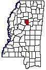
Montgomery County, which lies north of
the central part of the State, was established at a comparatively late
period, and on May 13, 1871, was carved from the counties of Carroll and
Choctaw. In 1874 a part of its own territory was taken and transferred
to Webster, then called Sumner County. The county was named in honor of
Gen. Richard Montgomery who fell in the assault on Quebec. It now contains
a superficial area of 398 square miles and is bounded as follows: On the
north by Grenada County, on the east by Webster and Choctaw counties, on
the south by Attala County and on the west by Carroll County. Its first
county officers were W.B. Peery, Eli P. Cartlidge, Thomas C. Curry, James
Thomas, Supervisors; John C. McKenzie, Sheriff; Thomas C. Blackmore, Clerk
of the Chancery Court; Henry Harris, Clerk of the Circuit Court; T.B. Brown,
Assessor; F.M. Shyrock, Treasurer; W.H. Parke, Superintendent of Education.
All of these officers were temporary appointments of Governor Alcorn, at
the time the county was first organized.
The largest town and the seat is Winona,
which is an incorporated city of 2,500 people, at the junction of the Illinois
Central and the Southern railways. The word Winona, is an Indian word
meaning first-born daughter. It has a number of industrial enterprises
and is located in the center of a rich farming region. A few of the other
towns in the county are Duck Hill, Kilmichael, Thrailkill, Stewart, Eskridge,
Lodi, Minerva, Poplar Creek, Fox, Carnegie, Sawyer and Alva. Good transportation
facilities are provided by the two railroads above mentioned. The Big Black
River runs through the southeastern part; the other streams are Bogue-Hays,
Mulberry, Lewis, Wolf and many other smaller creeks. The general surface
of the land is undulating, a small part is hilly. The soil is a rich, dark
or yellow loam, on the bottoms a dark alluvial.
The census figures of 1920 indicate that
the agricultural properties of Montgomery County are valued at more than
$5,000,000; that its crops in 1919 realized $2,317,000, and that in the
order of importance were the cereals, hay and forage and vegetables. Chiefly
contributing to the value of its live stock (over $1,000,000) were the
mules, dairy cattle and horses.
The population of Montgomery County has
changed but little since its first national census was taken in 1880. It
was largest in 1910 (17,706), but in 1920 was about the same as in 188013,805
and 13,348, respectively.
NESHOBA COUNTY
Chapter XLIV, pages 796-797
Situated a little east of the central part
of the State, Neshoba County may be classed as one of the interior counties
of the State. The county has a land surface of 561 square miles. It was
formed December 23, 1833, from the territory ceded by the Choctaw nation
three years earlier, and a desirable class of emigrants from the older
states and the other parts of Mississippi came into the region at an early
day. It has a rich Indian history. The name Neshoba is an Indian word
meaning grey wolf. The county is in the form of a square, containing
sixteen townships, and is bounded on the north by Winston County, on the
east by Kemper County, on the south by Newton County and on the west by
Leake County. It originally embraced the townships numbered 5, 6, 7, 8,
9, 10, 11, and 12, of ranges 10, 11, 12 and 13. February 5, 1836, townships
5, 6, 7 and 8 were taken from it to form the present county of Newton.
Its interests are almost exclusively agricultural. The Gulf, Mobile &
Northern line traverses the county from north to south, and the Jackson
& Eastern takes a loop through its southwestern corner, via Neshoba.
Neshoba County is virtually a country of farms and rural settlements, and
country life is retired and restful.
The county seat is Philadelphia, a thriving
incorporated city of 1,600 people located near the center of the county.
A few of the villages worthy of mention are Dixon, Neshoba, Stallo, McDonald
and Burnside. The county is well watered by the Pearl River and the numerous
tributary creeks which form its head streams. It is a pleasant undulating
and hilly region with level reaches along the river and creek bottoms.
The soil varies a good deal in composition; it is fertile on the bottoms,
fairly good on the rolling lands and sandy and light in the hills, with
a clay subsoil. The products are those common to the central part of Mississippi;
corn, cotton, oats, wheat, peas, sweet and Irish potatoes, sorghum, and
a large quantity of fruits and vegetables raised for home consumption.
Large beds of green sand marls have been found in the county and there
are numerous reed brakes. Considerable attention of late years has been
given to raising live stock and the industry has assumed considerable proportions.
Neshoba Countys standing as an agricultural
section of the State may be inferred from the reports of the census bureau
in 1920, which cover the year 1919. In the latter year, the value of its
farm property was given as more than $6,000,000 and that of its crops at
$2,825,000. About half of the latter sum was covered by cereals and vegetables.
The value of the live stock was placed at $1,288,000; the mules of the
county being valued, at $363,000, the dairy cattle at $252,000 and the
horses at $185,000.
Neshobas population has steadily increased,
with the exception of the half decade covered by the War for Southern Independence
which stripped it of its young men. In 1850, it was 4,728; in 1870, 7,439;
1890, 11,146; 1910, 17,980; 1920, 19,303.