.
Marshall
County
Marshall County
Chapter XLIV, pages 787-791
One of the far northern counties of the
State, on the Tennessee border, Marshall County was established February
9, 1836, the year in which the Chickasaw session of 1832 was divided by
the commonwealth into political organizations. It was named for Chief Justice
John Marshall and formerly included within its area a considerable portion
of Benton, Tate, and several other counties. The act creating the county
defined its limits as follows: "Beginning at the point where the line of
the basis meridian intersects the northern boundary line of the State,
and running thence south with the said basis meridian line, to the center,
of township 6; thence west through the center of township 6, according
to the sectional lines, to the center of range 5 west; thence north through
the center of range 5 west, according to the sectional lines, to the northern
boundary line of the State, and thence east with the said boundary line,
to the beginning."
Its original area was about 23 townships
or 828 square miles. In 1870 it gave up part of its territory on the east
to Benton County, and in 1873 it gave up another portion of its area to
assist in the formation of Tate County, and received in lieu of the portion
surrendered to Tate, all that portion of De Soto County lying within townships
1 and 2, R. 5 west. Subsequent slight modifications of its boundaries have
resulted in reducing its area to 689 square miles. It is an attractive
stretch of country, located on the extreme northern border of the State
next to Tennessee, and is bounded on the east by Benton County, on the
south by Lafayette County, the Tallahatchie River forming part of the dividing
line in the southeastern corner, and on the west by Tate and De Soto counties.
The following is a list of its civil officers
for the year 1837: William H. Bourland, Clerk of Probate; James C. Alderson,
Clerk of Circuit Court; Thomas Lane, Probate Judge; M.J. Blackwell, Surveyor;
Frederick Wells, Assessor and Collector; Thomas J. Oliver, Treasurer; Benj.
Daluron, Coroner; T. McCrosky, Sheriff; G.W. Graham, Ranger; Dickson Rogers,
Henry White, Wm. Hicks, W.C. Edmundson, E.H. Patts, Board of Police; John
Roaks, T.L. Treadwell, D.E. Brittonum, Henry Moore, Milton P. Johnson,
Geo. W. Wry, T.M. Yancy, J.C. Randolph, J.B. Cockran, Robert Carson, Justices
of the Peace; John P. Planes, James Rhodes, Sillmane Weaver, John M. Malone,
Lewis Johnston, Constables.
Marshall County received its full share
of settlers during the early rush of emigration into the newly opened Chickasaw
cession. By the year 1840, it had a population of about 17,500, and by
the year 1850 the population was 29,089. Among these were many prominent
families and wealthy planters.
Three of the earliest settlements were
at Tallaloosa, located about 8 miles southwest of Holly Springs, on the
Pigeon Roost Creek, Waterford, one mile west of the station of the same
name on the Illinois Central railroad, and the place of muster for the
militia of that part of the State; and Hudsonville, about 4 miles southwest
of old Lamar, on the stage road from Lagrange, Tennessee, to Holly Springs,
Mississippi, and 2 miles southeast of the station of the same name on the
Illinois Central railroad. All three places are now practically extinct.
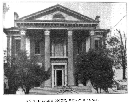
Its chief town and county seat is Holly
Springs, the "City of Flowers," containing 2,100 inhabitants reflecting
the States best type of population and located near the center of the county
at the junction of the Illinois Central, and the Kansas City, Memphis &
Birmingham railways. Addison Craft, one of the pioneers of Marshall County,
states that it was named by the roadsters who traveled from the Chickasaw
Bluffs to the land office at Pontotoc. At this spot they found an extensive
ravine covered with holly, and having some thirty or more clear, cold springs
of water. It was an excellent camping ground and the camp was called Holly
Springs. It is the center of a good dairy and market-garden region, and
has a number of flourishing industries. It is also the seat of the Mississippi
Synodical College, and the North Mississippi Experiment Station. It was
here that General Van Dorn made his celebrated raid on the Federal stores
left behind by Grant, December 20, 1862. The history of the region appears
in several places in the course of the narrative history of the State.
Some of the other more important settlements of Marshall County are Byhalia,
Potts Camp, Redbanks, Waterford and Hudsonville.
The region lies in the yellow loam district,
its surface is undulating, level on the river and creek bottoms. The soil
on the bottom lands is fertile, on some of the upland ridges poor and sandy
and on many of the table lands quite productive. Excellent pasturage is
to be had and the live stock industry is very profitable. Its close proximity
to the large city of Memphis (50 miles), and the two important lines of
railroad which cross its surface, the Illinois Central and the Kansas City,
Memphis & Birmingham, give it a ready outlet for its numerous products.
The more important water courses in the county are the Tallahatchie River
on the south and its tributaries, and the numerous creeks flowing west,
which constitute the headwaters of the Coldwater River.
Marshall is one of the old and prosperous
counties of northern Mississippi. The census issued by the national government
in 1920 indicates as much. From the statistics of that report it is learned
that the entire farm properties of Marshall County were valued at $11,000,000,
and of this amount the live stock was figured at nearly $2,000,000. Approximately,
the proportion of the value of the live stock was credited as follows:
Mules, one-third; horses, one-fourth and dairy cattle about the same as
horses. Much good fruit is also raised in Marshall County, which has 18,000
bearing trees, the bulk of which are peach. Finally, it may be noted that
the farmers have adopted the prevailing custom in Mississippi of raising
vegetables both for home consumption and shipment; the value of that crop
in 1919 is given as $282,000.
On account of its various changes in territory,
the population of Marshall County has not increased since the taking of
the first census in 1850; in fact, it was larger in 1850 (29,689) than
in 1920 (26,105). At no time during this long period has the population
fallen below 26,000, although in 1880 it passed 29,000.
Return to
County History Index
MSGenWeb Home
Source:
Mississippi The Heart of the South - By Dunbar Rowland, LL.D - Director
of the Mississippi State Department of Archives and History. Vol.
II Illustrated. Chicago-Jackson; The S. J. Clarke Publishing
Company, 1925. Public Domain
Copyright Notice: All files
and photographs on this site are copyrighted by their creator and/or contributor,
unless otherwise noted. They may be linked to but may not be reproduced
on another site without specific permission from The MSGenWeb State Coordinator
or the Assistant State Coordinator, and/or their contributor. Although
public information is not in and of itself copyrightable, the format in
which they are presented, the notes and comments, etc., are. It is however,
quite permissible to print or save the files to a personal computer for
personal use ONLY.
  
|
