.
Madison
County
MADISON COUNTY
CHAPTER XLVI, pages 782 - 784
Situated in the west-central part of the
State, Madison County was established January 29, 1828, and named for James
Madison, fourth President of the United States. Embraced within the territory
ceded by the Choctaws in 1820, and long known as the "New Purchase," it
was originally a part of the old county of Hinds. In 1823 Hinds surrendered
a large section of its area to form the county of Yazoo, and five years
later, that portion of Yazoo lying east of the Big Black River, was taken
to form the county of Madison. The act creating the county recites that
"So much of the county of Yazoo as lies east of the Big Black River, beginning
on the east bank of said river, where the Hinds County line strikes the
same; thence with the said line to Pearl River; thence up said river to
the Choctaw boundary line; thence with said boundary line, to where it
strikes the Big Black; thence down the Big Black River to the beginning."
December 23, 1833, the county was enlarged by adding "the territory south
of the line drawn from the western boundary of Leake County, through the
center of township 12 of range 5 east, and extended west to the old Choctaw
boundary, and thence west to the Big Black River, and west of Leake County."
February 22, 1840, the present boundary line between Madison and Hinds
counties was established.
Madison County has now an area of 725 square
miles. It is bounded on the north by the county of Attala, on the east
by Leake County, on the south by Rankin and Hinds counties, the Pearl River
on the southeast forming the boundary between Madison and Rankin; on the
west by Yazoo County, the Big Black River on the northwest forming the
boundary between it and Yazoo County.
Madison County is one of the richest farming
sections of the whole State and early attracted a large influx of settlers.
It had a population of 3,675 whites and 11,238 slaves as early as 1837,
and had 89,746 acres under cultivation in 1836. Many of the old settlements
of the region, such as Runnelsville, Williamsburg, Madisonville, Livingston
and Vernon, are now extinct or moribund. The first courts of the county
were held at Beatties Bluff, on the Big Black River, and boats ascended
the river to this point. The following men were appointed commissioners
to select and lay out a county seat, and contract for the erection of county
buildings: Jonah R. Doak, Robert Carson, Sr., Archibald McGehee, John P.
Thompson and William Wilson. The first permanent county seat was located
at the old town of Livingston, situated about 15 miles southwest of Canton,
and at one time the most important town in the county. It began to decay
when the county seat was changed to Madisonville.
The present county site was finally established
at Canton, near the center of the county. Canton is a thriving town of
3,200 people, on the Illinois Central railroad, has one of the largest
nurseries and floral establishments in the State, and is the center of
a locality where the growing of fruits and vegetables for market has assumed
large proportions. Some of the other important towns in the county are
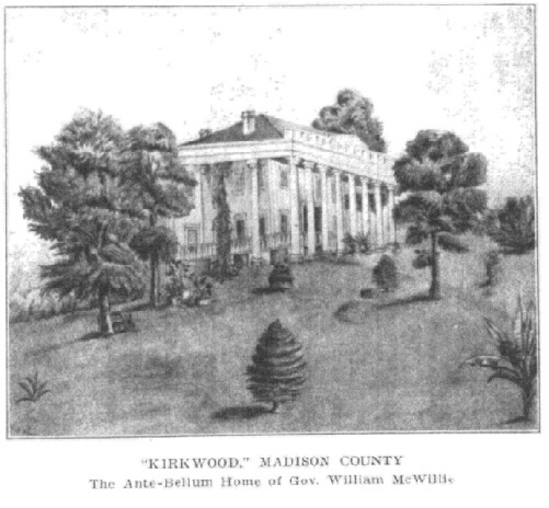
Madison, Ridgeland, Flora, Sharon and Miliville. In the northeast corner
of the county formerly stood the old historic home of Governor McWillie,
"Kirkwood," long known as one of the most beautiful and hospitable homes
in the South, and a refuge for its war-worn sons during the War for Southern
Independence. General Quitman, Governors Matthews, Foote, Pettus, and McRea,
President Davis and many others of note have been entertained within its
portals.
The main line of the Illinois
Central railway runs through the center of the county, and a branch line
of the same road runs from Jackson to Yazoo City and cuts across the southwestern
corner. Besides the two large rivers already.mentioned, numerous tributary
creeks afford the region ample water power, the power on Kentuctah and
Doaks creeks being especially good. The region is gently undulating and
the soil various in character, with a clay subsoil; much of it is very
rich, and, on the river and creek bottoms, of an alluvial quality. In the
southern part deposits of limestone and mans have been discovered. Large
quantities of peaches and strawberries are grown along the line of the
Illinois Central railway in this county, and shipped to the northern markets.
Pears, apples, figs and other fruits are also raised in abundance and do
very well.
Madison County is a very productive agricultural
section of the State, and is especially well known as a live stock region
and adapted to the raising of peaches and apples. Strawberries are also
cultivated readily and with profit. To the value of its live stock (estimated
at $2,523,000), the chief contributions were made by the following: Mules,
$870,000; horses, $547,000; beef cattle, $428,000; dairy cattle, $412,000.
Return to
County History Index
MSGenWeb Home
Source:
Mississippi The Heart of the South - By Dunbar Rowland, LL.D - Director
of the Mississippi State Department of Archives and History. Vol.
II Illustrated. Chicago-Jackson; The S. J. Clarke Publishing
Company, 1925. Public Domain
Copyright Notice: All files
and photographs on this site are copyrighted by their creator and/or contributor,
unless otherwise noted. They may be linked to but may not be reproduced
on another site without specific permission from The MSGenWeb State Coordinator
or the Assistant State Coordinator, and/or their contributor. Although
public information is not in and of itself copyrightable, the format in
which they are presented, the notes and comments, etc., are. It is however,
quite permissible to print or save the files to a personal computer for
personal use ONLY.
  
|
