.
Lowndes
County
LOWNDES COUNTY
CHAPTER XLVI, pages 778 - 782
The county of Lowndes, situated in one
of the most historic regions of north Mississippi, lies along the Alabama
border in the north-central tier of counties. It was erected January 30,
1830, and was named for William J. Lowndes, famous congressman and public
character of South Carolina. It was originally the southern part of Monroe
County and embraced within its area a part of the present county of Clay.
The act creating the county defined its boundaries as follows: "All that
portion of Monroe County lying south of a line commencing at a point on
the State of Alabama, where a line running due east from Robinsons Bluff,
on the Buttahatchie River, would strike the state line of Alabama; thence
from said point, due, west, to said Robinsons Bluff; thence down the said
river to its mouth; thence west, to the western boundary line of the county
of Monroe, as designated by the act of 1829, extending into the territory
occupied by the Chickasaw and Choctaw tribes of Indians, shall form a new
county, etc." December 6, 1831, its limits were extended "to commence on
the State line of Alabama, at the house of William Lucas, and to run from
thence in a northwest direction, so as to cross the Robertson road, at
a place on said Robertsons road, known by the name of Wilsons stand,
so as to include said Wilsons stand; and from thence on a direct line
from the place of beginning until said line strikes the Natchez Trail;
and from thence north, along the said Natchez Trail to the northern boundary
line of said county of Lowndes." And again December 23, 1833, it was extended
to include "all the territory south of a line, running from the junction
of the Buttahatchie River, with the Tombigbee River, to the northeast corner
of Oktibbeha County, and east of and between Oktibbeha County and the Tombigbee
River and north of Noxubee County." Finally in 1872, its northern and western
limits were modified, when some of its area was taken to form part of the
county of Clay. This excision reduced its area to 499 square miles. The
Lowndes County of the present is therefore bounded north by Monroe County,
east by Pickens and Lamar counties, Alabama, south by Noxubee County and
west by Oktibbeha, Clay and Monroe counties.
The first County Court convened at Columbus,
April 12, 1830, and consisted of Thomas Sampson, President, and Micajah
Brooks, Samuel B. Morgan, Associates. Other county officials the same year
were R.D. Haden, County Clerk; Nimrod Davis, Sheriff; John H. Morris, Assessor
and Collector; O.P. Brown, County Treasurer and William L. Moore, County
Surveyor.
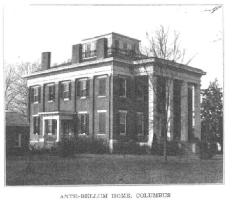
Lowndes County has long been known as one
of the most cultured prosperous and wealthy sections of the State. As early
as 1817, some scattered settlements were made in this region, and in 1818
Dr. Gideon Lincecum built the first house on the present site of Columbus.
His autobiography contains the following reference to this incident: "We
made preparations to set out (from Tuscaloosa, Alabama) on November 1,
1818. In the afternoon of the twelfth day we reached the Tombigbee River,
three miles above where Columbus now stands, and there I made my camp.
Father went two hundred yards below and pitched his tent. As soon as I
got my house done, I went over the river to see the Choctaws. After the
road was made by the government from Nashville to Natchez, which crossed
the river where Columbus now stands, I went down there to see what kind
of a place it was. I thought it was an eligible town site. I was so fully
impressed with this belief, that I went home and rived a thousand boards,
put them on a raft and floated them down the river with the intention of
building a snug little house on a nice place I had selected. I was not
the oniy person that had noticed the eligibility of that locality, for
when I got down to the place, a man named Coldwell was about landing a
keel-boat. He was from Tuscaloosa, Alabama, and had a cargo of Indian goods
which he calculated on opening on that bluff as soon as he could build
a house to put them in. I proposed to sell him my boards and he in turn
proposed to sell me his goods. After some parleying, I took the goods,
hired his boat hands and went to work, and in three days had knocked up
a pretty good shanty. We soon got the goods into it and commenced opening
boxes and taking stock; but the Indians heard of the arrival and flocked
in by hundreds. I began selling whiskey and such goods as we had marked,
and this prevented us from work in the day time. Having only night time
to work on the invoice, it took ten days to get through, but I had sold
enough to pay the first installment and Coldwell went home highly pleased.
I bartered with the Indians for every kind of produce, consisting of cowhides,
deer skins, all kinds of furs, skins, buck horns, cow horns, peas, beans,
peanuts, pecans, hickory nuts, honey, beeswax, blowguns, etc. Every article
brought cash at 100 per cent, on cost. I made frequent trips to Mobile
for sugar, coffee and whiskey, staple articles in the Indian trade, but
all my drygoods came from the house of Dallas and Wilcox, Philadelphia."
That portion of the county lying east of
the Tombigbee River is older historically by fourteen years than the western
part, as the former came under territorial control by the Choctaw cession
of 1816, while the western part was not acquired until the Choctaw cession
of 1830. The first white man to reside permanently upon the soil of what
is now Lowndes County, was Maj. John Pitchlyn, the son of an English army
officer, who was reared from boyhood among the Choctaws, and was in after
life the sworn interpreter of the United States in various treaties and
dealings with the Choctaws.
The following is a list of the pioneer
settlers on the east side of the Tombigbee, as compiled by William A. Love,
in his interesting sketch of Lowndes County: Settlers in 1817, John Halbert,
Silas McBee, Benjamin Hewson; 1818, Thomas Cummings, William Butler, Peter
Nail, William H. Craven, Newton Beckwith, John McGowan, Westley Ross, A.
Cook, James Brownlee, John Portwood, Thomas Kincaid, Ezekiel Nash, Wm.
Weaver, Thomas Cooper, Cincinnatus Cooper, Conrad Hackleman, David Alsop,
Spirus Roach, Thomas O. Sampson, Hezekiah Lincecum, Gideon Lincecum; 1819,
Robert D. Haden, Ovid P. Brown, Richard Barry, Dr. B.C. Barry, Martin Sims,
Bartlet Sims, William Cocke, Thomas Townsend, William L. Moore, William
Ellis, William Leech, John Egger.
In the extreme southwestern part of the
county was an old postoffice known as Daileys Cross Roads for its postmaster
John A. Dailey. Another old postoffice that antedated the building of the
railways, was Prairie Hill, in the west central part of the county. The
early settlements at Plymouth, West Port, Nashville and Moores Bluff,
are now all extinct, but were important trading points on the Tombigbee
River in the early history of the county. These early settlers were attracted
from the older states by the richness of the county, its contiguity to
a fine navigable stream, its mild climate and the fact that the "Mliitary
Road," from New Orleans to Nashville, opened by U. S. troops 1817-1820
offered ready means of access to the region. A little later, when the Indian
lands were offered for sale, settlers came in rapidly, and as early as
1837, the county had a population of 5,495 whites and 7,362 slaves.
Columbus was an incorporated town
in 1822 and by 1837 had a population of about 3,500 and was the center
of a thriving trade for all the surrounding region. It is the county seat
and is a thriving place of 10,000 inhabitants, located on the east bank
of the Tombigbee River, at the junction of the Mobile & Ohio, and the
Southern railways, giving it excellent shipping connections north, south,
east, and west. It is an unusually attractive city and the home of much
wealth and culture. It is one of the largest manufacturing centers in the
northern part of the State. Besides its industrial enterprises, it is the
seat of one of Mississippis most noteworthy schoolsThe Industrial Institute
and College, founded in 1884 and lately renamed the Mississippi State College
for Women. This college possesses a fine group of buildings and has been
highly successful in carrying out the purposes of its founders, the industrial
and collegiate training of young women. Some of the more important villages
in the county are Artesia, Crawford, Caledonia, Mayhew and Penn. The Mobile
& Ohio railroad crosses the county in two directions and the Southern
railroad runs from northeast to southwest until it reaches Columbus, then
northwest to Westpoint. The Tombigbee River flows through the county and
is navigable to Columbus, and, with its numerous tributaries, gives the
county plenty of water advantages. About one-half of the county lies west
of the Tombigbee River in the black prairie belt.
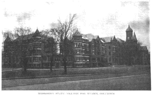
[Formerly the Mississippi
Indistrial Institue and College, iIt was renamed
Mississipi State College
for Women in 1920. It achieved university status in 1974.]
In 1850, Lowndes County had a population
of 19,544; in 1870, of 30,502; in 1880, after it had given up part of its
territory to Clay County, 28,244; in 1900, 29,095; in 1920, 27,632.
It is a substantial county both industrially
and agriculturally. The county has 55 manufactories, the majority of them
lumber mills; their output in 1919 amounted to more than $3,500,000, and
the wages paid the 1,300 workers, $947,000. Columbus, the chief industrial
center, employed about half the wage earners in the county, and the output
of its 27 establishments was valued at $2,150,000. On the other hand, the
value of the crops harvested throughout the county was $3,950,000, of which
the cereals accounted for $905,000 and the hay and forage, $770,000. Its
live stock was valued at $1,493,000, of which the dairy cattle were listed
as worth $309,000. The value of all farm property was estimated at $13,736,000.
Return to
County History Index
MSGenWeb Home
Source:
Mississippi The Heart of the South - By Dunbar Rowland, LL.D - Director
of the Mississippi State Department of Archives and History. Vol.
II Illustrated. Chicago-Jackson; The S. J. Clarke Publishing
Company, 1925. Public Domain
Copyright Notice: All files
and photographs on this site are copyrighted by their creator and/or contributor,
unless otherwise noted. They may be linked to but may not be reproduced
on another site without specific permission from The MSGenWeb State Coordinator
or the Assistant State Coordinator, and/or their contributor. Although
public information is not in and of itself copyrightable, the format in
which they are presented, the notes and comments, etc., are. It is however,
quite permissible to print or save the files to a personal computer for
personal use ONLY.
  
|
