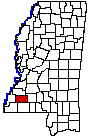
FRANKLIN COUNTY
Chapter XLV, pages 723-724
This is one of the oldest of the counties,
having been established on the 21st of December, 1809, while David Holmes
of Virginia was serving as territorial governor. The original act of the
General Assembly recites that the part of Adams included within the following
boundaries shall be known by the name of Franklin County:
"Beginning at the point where the basis-meridian
line intersects the river Homochitto, and pursuing the said meridian line
until it intersects the line dividing the counties of Adams and Jefferson,
thence pursuing the last mentioned line to the western boundary of Washington
County, thence pursuing the last mentioned line until it intersects the
northern boundary of Amite County, thence along the said last mentioned
boundary line to the point where it intersects the said river Homochitto,
and thence Pursuing the meanders of said river to the beginning." Benjamin
Franklin gave his name to the county.
The northern, southern and western lines
of the county have not been changed, but its extensive eastern area has
been taken to form new counties and the present eastern line of the county
is drawn from a point one mile east of the range line between ranges 5
and 6 east, south on section lines one mile from said range line to the
township line between townships 4 and 5. The area now embraced within its
limits formed a part of the old Natchez District, whose eastern limits
were near the present eastern boundary of the county.
The names of a few of the early civil officers
of the county were: Bailey E. Chancy, Daniel Cameron, Bartlett Ford, Joseph
Robertson, David Thompson, John Thompson, Jesse Guice, George Knox, Justices
of the Quorum (1818-1821); John G. Witherspoon and Charles C. Slocumb,
Sheriffs; Peter McIntyre, Surveyor; George Knox, Stephen Owens, George
Gray, Wm. B. Smith, Abner Read, Thos. Meridith, Daniel Guice, Justices
of the Peace; Moses Martin, William Collins, Treasurers; John Cameron,
Judge of Probate, and Bartlett Ford, Justice of the County Court. Its pioneers
did their full share in the early upbuilding of the Commonwealth and it
was ably represented in the constitutional convention of 1817 by John Shaw
and James Knox.
The land area of the present county is
547 square miles. It is bounded on the north by Jefferson and Lincoln counties,
on the east by Lincoln County, on the south by Amite and part of Wilkinson
County and on the west by Adams County. The county seat is located at the
town of Meadville, in the center of the county, a place of 300 inhabitants
named for Cowles Mead, second secretary of the Mississippi Territory. Meadville
is on the Mississippi Central railroad, which crosses the county from east
to west and effects a junction at Roxie with the Yazoo & Mississippi
Valley line, running north and south. Lucien and McCall are smaller incorporated
towns in the eastern part of the county on the Mississippi Central line.
The Homochitto River traverses it from
the northeast to the southwest, forming its border line for a few miles,
and with the numerous tributary streams, provides the county with ample
water facilities. The surface of the county is undulating, and broken and
hilly in parts, with an extensive area of level bottom lands. The timber
consists of long leaf pine, oak, hickory, walnut, poplar, magnolia, cypress,
etc. The soil is that common to the long leaf pine region of the State,
being rather light and sandy in the hills, a little more compact on the
lower lands and quite fertile in the creek and river bottoms. The county
is well adapted to dairying and stock raising. Its social life is quiet
but progressive and it is well supplied with schools and churches.
Franklin County is generally composed of
agricultural and rural communities. The total value of its farm property
is $4,652,000, and its crops have an annual productive worth of nearly
half that amount. Its live stock is valued at $1,124,000.